Can I fish here, right now, for what, and how many?
Tap any saltwater spot in British Columbia and get one plain verdict per species: open, closed, or release only, with the limit, the size and the gear rule attached. Read from official sources, cached on your phone, still answering when the signal drops.
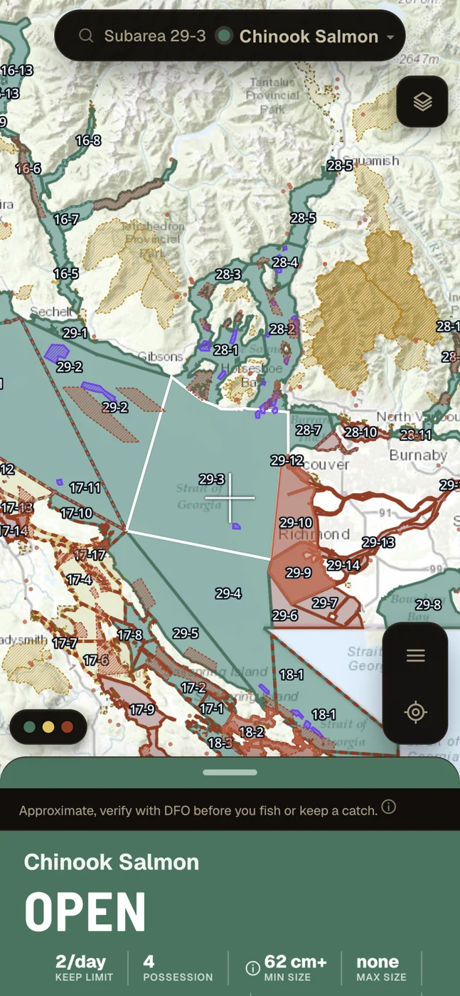
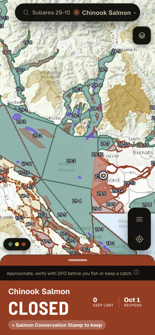
Two subareas, the same species, the same day. Unedited captures from the app on 12 September 2026, cropped to the verdict on small screens, and both verdicts are re-checked against the live rule set every time this page is built. Regulations change: open the app for today's answer. Basemap in the captures: Esri, USGS, NOAA, and OpenStreetMap contributors.
- Coverage
- BC tidal waters
- Checked
- Hourly, 9 AM to 9 PM Pacific
- Cost
- Nothing today
- Account
- Not needed
- Offline
- Yes, after first load
- Freshwater
- Invite-only preview
Four colours, and one of them means we are not sure.
A colour on this map is a regulatory claim, never decoration. Each one is paired with its word, so the verdict still reads if you cannot separate the colours.
The species you picked can be kept here, right now. This is the only colour that says keep, and it is never shown on an assumption.
You may be allowed to fish, but there is a condition you have to read: release only, a gear or bait restriction, a season about to open, or a rule we could not confirm. When we cannot confirm something, it lands here rather than on open.
The rule has a date window rather than a plain yes or no, so the card shows you the window and what changes when it ends.
No fishing for that species here, right now. The card gives the reason, the reopening date when there is one, and a link to the notice that closed it.
The freshwater preview adds a fifth, a near black for water that is closed permanently rather than seasonally, so a sanctuary never reads like a closure that lifts next week.
Government data in, plain answer out. Nothing invented in between.
Every rule traces back to an official page, and the card links to the one it was read from. We read those pages verbatim rather than paraphrasing them.
Source counts above are from the shipped data on 13 September 2026.
A data refresh has to clear every one of these against the official sources before it can ship. If a single check fails, the refresh is rolled back and yesterday's data stays up, rather than a wrong rule going out. Counted from the gate run on 13 September 2026. It only ever grows: every bug we fix ships with a new check so that it cannot come back.
It fails to verify, not to open
We treat a false open as the one unacceptable failure. Where a rule cannot be confirmed, or an area is not modelled yet, the app says verify and sends you to the official notice instead of showing a confident open. We have shipped false opens before, and every one we found was fixed and pinned with its own test so that it cannot come back quietly. If you find a rule we have wrong, there is a report button inside the app, and it takes no account.
It shows its own age
Every card carries the timestamp of the source behind it, down to "checked 9 minutes ago", and the app warns you on screen if a check has not succeeded in 24 hours. We look for new notices, closures and openings every hour from 9 AM to 9 PM Pacific, with a full pass overnight.
What it covers today.
DFO tidal subareas, every one of them carrying a resolved verdict, found from the exact point you tap rather than the area you are near
Rockfish conservation areas, drawn on the map and folded into the verdict
Shellfish contamination closure zones, attached to every bivalve verdict
Tidal species in the catalogue, finfish and invertebrates, each with its own limits
DFO area pages read verbatim, each stored with its source link and fetch time
Counted from the shipped data on 13 September 2026. The rule set grows, so treat these as a snapshot rather than a constant.
Built for where there is no bar of signal.
The rules, the boundaries and the closure areas download to your phone the first time you open the app. After that the verdict, the species limits, the boundary lines and the closures all resolve with no connection at all. Put the phone in airplane mode on the water and it still answers.
Do the first load on wifi
That first download is about 102 MB of coastline, boundaries and the full rule set, so get it before you leave the dock. Tides, weather and satellite imagery still need a connection, apart from map tiles you have already looked at.
Your spots stay yours.
Other apps keep your marks on their servers. We cannot, because there is nowhere on our side for them to go.
It never leaves the phone
Your saved spots, catch log, favourite species, imported sonar tracks and licence photo live in your phone's own storage. They are never uploaded to us, never synced between devices, and we keep no copy.
We do not track where you go
Your GPS fix is used on the device, to centre the map and work out which management area you are in. We never transmit or store a track of your movements. One thing leaves the phone, and only for the point on the map you are looking at: when you open tides or weather, the coordinates of the point go straight from your phone to DFO, Environment and Climate Change Canada and MET Norway to fetch the forecast, rounded to about a kilometre first so the request never carries your exact spot.
No ads, no brokers, no cross-app tracking
There is no ad network, no data broker and nothing that follows you across other apps or sites. There is also no product analytics of any kind: the app counts nothing, sends no usage events and uses no analytics service, on any build. We used one until 13 September 2026 and removed it, because any analytics service necessarily receives your IP address and nothing in the app could prevent that. The full reasoning is in the privacy policy.
What Catchable does not do.
Saying this plainly is part of the product. If you know exactly where the edges are, you can trust what sits inside them.
It is not the official regulations
It is a careful reading of them. If this app and an official source ever disagree, the official source wins, every time.
Freshwater is an invite-only preview
What everyone gets covers BC tidal waters. Tap a river or a lake and the app tells you so. Freshwater sits behind an invite code while it is built, running on the same engine and read from the BC synopsis and DFO's freshwater salmon pages. It is going in water by water, it deliberately over-restricts where a boundary has not been placed precisely yet, and some waters are not modelled at all. Invites are not open at the moment.
It is not a navigation or safety tool
Depth, tide, wind and the shelter estimate are approximate and are not for navigation. Carry the charts and the gear you would carry anyway.
It does not send you alerts yet
Closure and opening alerts are built into the app, but the service behind them is not switched on, so nothing will notify you today. Check before you go.
It does not identify your fish from a photo
It gives you field marks and side by side comparisons for the dangerous look-alikes, like yelloweye against other rockfish, which lowers the odds of an honest mistake. It does not make the call for you. If you cannot confirm it, let it go.
It does not back up your spots
They live on your phone only. That is the privacy promise and it is also the trade-off: clear the app's data and they are gone.
It cannot charge you
There is no paywall in the app and nothing in it that can take a payment. No account, no card, no trial to start. Paid tiers are planned, and when they exist the price will be shown in Canadian dollars with the renewal term and how to cancel, before you confirm anything. Our intent is that the core verdict stays free.
Standing caution
Catchable is not a substitute for the official regulations. It is a reading of DFO and Province of BC regulatory sources, kept as current as we can make it and checked against thousands of automated assertions on every refresh. Rules change, including in season and without notice, and our coverage has known gaps, set out in Notes 1 to 7 above.
Always verify against the official DFO Fishery Notices and the current BC Freshwater Fishing Regulations Synopsis before you fish or keep a catch, and when the app says verify, verify. You are responsible for fishing legally and for holding the correct licences and stamps.
Catchable is not affiliated with, endorsed by, or connected to Fisheries and Oceans Canada, the Province of British Columbia, or any government body.
Open it and tap your spot.
No account, nothing to install, nothing to buy. It opens in your browser, and you can add it to your home screen so it behaves like any other app on the water.
Open the app